ShopDreamUp AI ArtDreamUp
Deviation Actions


Suggested Deviants


Suggested Collections


You Might Like…


Featured in Groups


Description
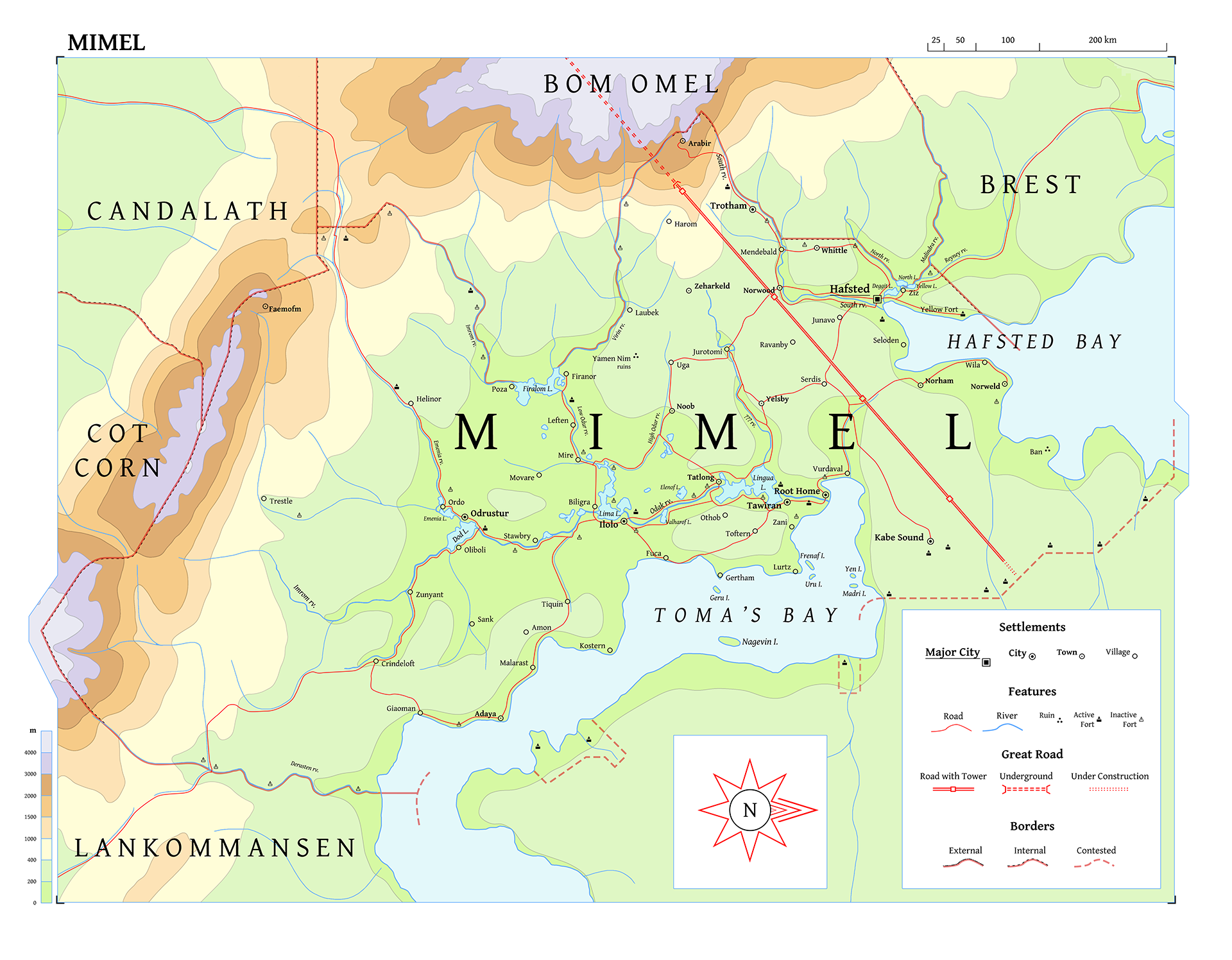
A map of Mimel, in the north-east reaches of Ilulnar.
Low-lying and marshy, the area has never been wealthy or well-organized, partially due to its adjacency to the Old Forest. Until a century ago, nearly to the day, the land was split in two across the great River Odak - the North calling itself High Mimel and the South calling itself Low Mimel. The unification of these lands took the form of a royal marriage, and not 30 years later the true King of Mimel would inherit and make permanent this bond. However, this was not to last.
Ir-Ailon is the new empire of Ilulnar. Founded in 943 by the dwarf Ural "the Seer", it has been wildly successful, completing in a few decades what other rulers have only dreamed of for centuries - the unification of the entire island. 20 years ago, in 956, the lands of Mimel were overrun and incorporated, its Kingdom dissolved and its petty lords scattered, and three years ago the conquest of the neighbouring Old Forest began. Though Ural is known to be the absolute ruler of his empire, it is also known that he delegates to and takes advice from a council of seven. However, not much is generally known about them, other than that they hail from around the world.
One thing that is very well known about Ir-Ailon, both within and without, is its Great Roads. A network of long, straight roads connect the major settlements of the island, carved into or built over the landscape, all of it designed and defended like a fortress. These began years before the empire, at first as tunnels under mountains to connect the great mountain-homes, but they expanded as the empire did. Two Great Roads are currently under construction: North, towards the Old Forest, and West, across the broken straits.
- - - - - - -
There's a bit that could be improved with this map, like adding additional labels, adjusting the roads in certain places, and other minor stuff, but I've decided to just leave it as-is for now so I can focus on other maps in the region. I'll be refining the style and dataset all the while, so once I do come back to this I'll have a lot more to add/change.
Image size
1920x1496px 1.18 MB
Comments5
Join the community to add your comment. Already a deviant? Log In
This is really cool. Please tell me there's more work related to this. Just a high level of detail. Great work so far!